MARKER ADVOCATES of TOBYHANNA TOWNSHIP
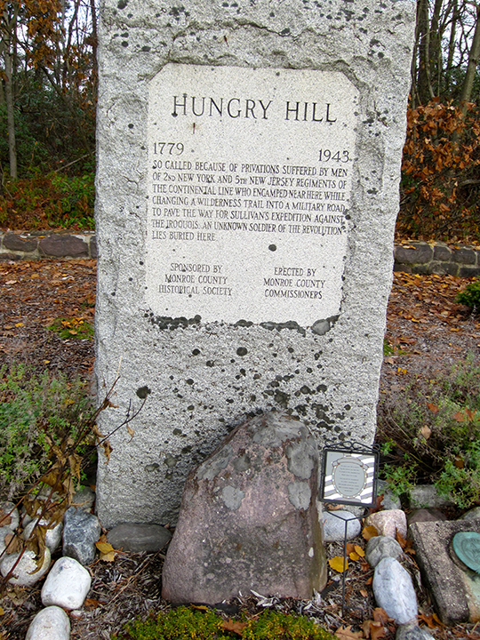
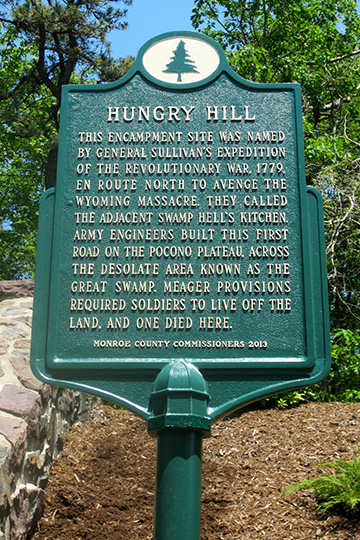
HUNGRY HILL


COMMEMORATES:
Revolutionary War memorial and gravesite of an unknown soldier of the Revolutionary War.
INSCRIPTION:
This encampment site was named by General Sullivan’s expedition of the Revolutionary War, 1779, en route north to avenge the Wyoming Massacre. They called the adjacent swamp Hell’s Kitchen. Army engineers built this first road on the Pocono Plateau, across the desolate area known as the Great Swamp. Meager provisions required the soldiers to live off the land, and one died here.
SPONSOR: 2013 | Monroe County Commissioners
MARKER DEDICATED: May 27, 2013
LOCATION: Sullivan Trail (Pa. Route 4004) near Pocono Pines, half a mile south of Pa. Route 940.
COORDINATES: 41° 06' 22.1"N 75° 26' 37.4"W
or 41.106139, –75.443722
GPS ADDRESS: 135 Sullivan Trail, Pocono Pines, Pa. 18350
READ MORE:
- Sullivan’s March blazed trail through plateau | Pocono Record, May 27, 2013
- The Historical Marker Database
- Pennsylvania Historical Marker Program
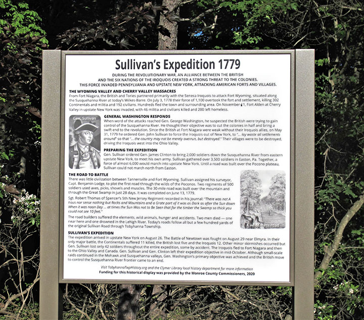
THE INTERPRETIVE PANEL:
A grant from the Monroe County Commissioners made possible an historical interpretive story panel for the Hungry Hill memorial that was installed in June 2021.
After reading the roadside marker installed close to the road, visitors can now learn more of the story of Hungry Hill, the building of Sullivan Road and Sullivan’s expedition, from the high-quality historical interpretive panel.
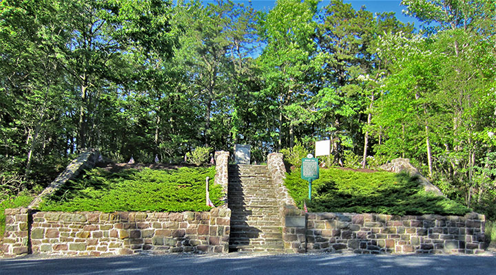
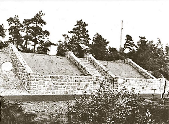
Hungry Hill is a Revolutionary War memorial created by Monroe County in 1943. The site honors a fallen soldier from the army regiments, and pays tribute to the two Continental army regiments that built Sullivan Road in May and June, 1779. The county commissioners designated Tobyhanna Township to be responsible for the site in 2019.
Sitting adjacent to today’s Sullivan Trail, (PA 4004), the elevated site is positioned within a wooded area, much like it would have been in 1779. The grave of a soldier who died while building the road, and his comrades, are honored by a large granite memorial.
After reading the roadside marker installed close to the road, visitors can now learn more of the story of Hungry Hill, the building of Sullivan Road and Sullivan’s expedition, from the high-quality historical interpretive panel.
Hungry Hill is a Revolutionary War memorial created by Monroe County in 1943. The site honors a fallen soldier from the army regiments, and pays tribute to the two Continental army regiments that built Sullivan Road in May and June, 1779. The county commissioners designated Tobyhanna Township to be responsible for the site in 2019.
Sitting adjacent to today’s Sullivan Trail, (PA 4004), the elevated site is positioned within a wooded area, much like it would have been in 1779. The grave of a soldier who died while building the road, and his comrades, are honored by a large granite memorial.

TOBYHANNA TOWNSHIP MARKERS:
- Agriculture
- Battle of Locust Ridge
- Blakeslee United Methodist Church
- Blakeslee Community Center
- Easton & Wilkes-Barre Turnpike
- Eschenbach Cemetery
- First Fire Company & Clymer Library
- First Schoolhouse
- Forest Products Industry
- General Sullivan Bridge
- The Great Swamp
- Harrison Amusement Park
- Hungry Hill
- Ice Harvesting Industry
- Isaac Stauffer – King of the Poconos
About the Tobyhanna Township Roadside Marker Program
The Tobyhanna Township Roadside Historical Marker Program is a community-wide, volunteer effort spearheaded by the Marker Advocates of Tobyhanna Township (MATT).
MATT is a nonprofit association dedicated to this program. Volunteers serving in committees seek the funding, research and write the text, install the markers, arrange for a public dedication and establish a long-term awareness campaign through a touring map and a web site.
Be part of our heritage — Donate an historical marker- Through identification of the important facets of our rich history ... existing and lost landmarks, important events and activities, and our people, we will realize the goal of a community-wide network of roadside historical markers. Our community can now and for future decades and generations appreciate our heritage.
- Each roadside historical marker will ensure the preservation of our local history and heritage, while providing an important educational opportunity that is accessible to the public, free of charge.
- This program will build community pride while enhancing “heritage tourism,” recognized as a strong and desirable sector of our economy.
Sponsors donating the full cost of a marker are permanently recognized on the bottom of the marker. Additional appreciation is shared with the community through a public dedication ceremony, as well as a touring map, web site and other materials.
For more information on becoming a sponsor:
Email us
For more information on becoming a sponsor:
Email us