MARKER ADVOCATES of TOBYHANNA TOWNSHIP
TOBYHANNA TOWNSHIP

COMMEMORATES:
The founding and early years of Tobyhanna Township.
INSCRIPTION:
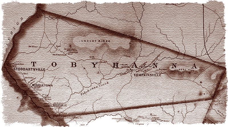
TOBYHANNA TOWNSHIP – The first permanent settlers were attracted to this area by an abundance of natural resources: land, trees, water. The township was incorporated in 1830, with 230 residents. It was named after Tobyhanna Creek, “A stream lined with alders” in Native American. Local industries were lumber, ice harvesting and farming, followed in the 20th Century by recreation, youth camps and vacation resorts.
SPONSOR: 2016 | Pocono Lions Club
MARKER DEDICATED: July 18, 2016
LOCATION: Flagpole and roadside park close to the traffic light in Pocono Pines. Old Route 940 across from Jennifer’s Salon and Rinehimer Construction.
COORDINATES: 41° 06' 17.1"N 75° 28' 13.78"W
or 41.104749, –75.470493
GPS ADDRESS: Old Route 940, Pocono Pines, PA 18350 [Note: GPS mapping for physical street address has been found to be incorrect).
READ MORE:
The founding and early years of Tobyhanna Township.
INSCRIPTION:
TOBYHANNA TOWNSHIP – The first permanent settlers were attracted to this area by an abundance of natural resources: land, trees, water. The township was incorporated in 1830, with 230 residents. It was named after Tobyhanna Creek, “A stream lined with alders” in Native American. Local industries were lumber, ice harvesting and farming, followed in the 20th Century by recreation, youth camps and vacation resorts.
SPONSOR: 2016 | Pocono Lions Club
MARKER DEDICATED: July 18, 2016
LOCATION: Flagpole and roadside park close to the traffic light in Pocono Pines. Old Route 940 across from Jennifer’s Salon and Rinehimer Construction.
COORDINATES: 41° 06' 17.1"N 75° 28' 13.78"W
or 41.104749, –75.470493
GPS ADDRESS: Old Route 940, Pocono Pines, PA 18350 [Note: GPS mapping for physical street address has been found to be incorrect).
READ MORE:
TOBYHANNA TOWNSHIP MARKERS:
- Agriculture
- Battle of Locust Ridge
- Blakeslee United Methodist Church
- Blakeslee Community Center
- Easton & Wilkes-Barre Turnpike
- Eschenbach Cemetery
- First Fire Company & Clymer Library
- First Schoolhouse
- Forest Products Industry
- General Sullivan Bridge
- The Great Swamp
- Harrison Amusement Park
- Hungry Hill
- Ice Harvesting Industry
- Isaac Stauffer – King of the Poconos
About the Tobyhanna Township Roadside Marker Program
The Tobyhanna Township Roadside Historical Marker Program is a community-wide, volunteer effort spearheaded by the Marker Advocates of Tobyhanna Township (MATT).
MATT is a nonprofit association dedicated to this program. Volunteers serving in committees seek the funding, research and write the text, install the markers, arrange for a public dedication and establish a long-term awareness campaign through a touring map and a web site.
Be part of our heritage — Donate an historical marker- Through identification of the important facets of our rich history ... existing and lost landmarks, important events and activities, and our people, we will realize the goal of a community-wide network of roadside historical markers. Our community can now and for future decades and generations appreciate our heritage.
- Each roadside historical marker will ensure the preservation of our local history and heritage, while providing an important educational opportunity that is accessible to the public, free of charge.
- This program will build community pride while enhancing “heritage tourism,” recognized as a strong and desirable sector of our economy.
Sponsors donating the full cost of a marker are permanently recognized on the bottom of the marker. Additional appreciation is shared with the community through a public dedication ceremony, as well as a touring map, web site and other materials.
For more information on becoming a sponsor:
Email us
For more information on becoming a sponsor:
Email us