MARKER ADVOCATES of TOBYHANNA TOWNSHIP
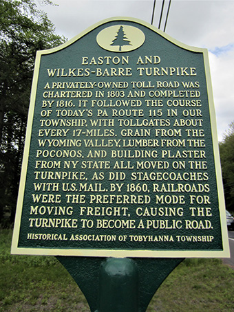
EASTON & WILKES-BARRE TURNPIKE

COMMEMORATES:
The first major road in the western part of the township, which opened it to commerce and development.
INSCRIPTION:
A privately-owned toll road was chartered in 1803 and completed by 1816. It followed the course of today’s Pa. Route 115 in our township, with tollgates about every 17 miles. Grain from the Wyoming Valley, lumber from the Poconos, and building plaster from N.Y. state all moved on the turnpike, as did stagecoaches with U.S. Mail. By 1860, railroads were the preferred mode for moving freight, causing the turnpike to become a public road.
SPONSOR:
Historical Association of Tobyhanna Township
MARKER DEDICATED: May 27, 2017
LOCATION:
5636 Pa. Route 115, south of Blakeslee traffic light, next to car wash
COORDINATES: 41° 05'23.6" 75° 35'21.6"W
or 41.089892, –75.589348
GPS ADDRESS: 5636 PA Route 115, Blakeslee, PA
READ MORE:
TOBYHANNA TOWNSHIP MARKERS:
- Agriculture
- Battle of Locust Ridge
- Blakeslee United Methodist Church
- Blakeslee Community Center
- Easton & Wilkes-Barre Turnpike
- Eschenbach Cemetery
- First Fire Company & Clymer Library
- First Schoolhouse
- Forest Products Industry
- General Sullivan Bridge
- The Great Swamp
- Harrison Amusement Park
- Hungry Hill
- Ice Harvesting Industry
- Isaac Stauffer – King of the Poconos
About the Tobyhanna Township Roadside Marker Program
The Tobyhanna Township Roadside Historical Marker Program is a community-wide, volunteer effort spearheaded by the Marker Advocates of Tobyhanna Township (MATT).
MATT is a nonprofit association dedicated to this program. Volunteers serving in committees seek the funding, research and write the text, install the markers, arrange for a public dedication and establish a long-term awareness campaign through a touring map and a web site.
Be part of our heritage — Donate an historical marker- Through identification of the important facets of our rich history ... existing and lost landmarks, important events and activities, and our people, we will realize the goal of a community-wide network of roadside historical markers. Our community can now and for future decades and generations appreciate our heritage.
- Each roadside historical marker will ensure the preservation of our local history and heritage, while providing an important educational opportunity that is accessible to the public, free of charge.
- This program will build community pride while enhancing “heritage tourism,” recognized as a strong and desirable sector of our economy.
Sponsors donating the full cost of a marker are permanently recognized on the bottom of the marker. Additional appreciation is shared with the community through a public dedication ceremony, as well as a touring map, web site and other materials.
For more information on becoming a sponsor:
Email us
For more information on becoming a sponsor:
Email us